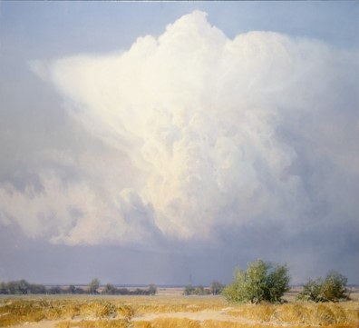
Summer Thunderstorm. 40 x 44.
In New Mexico when our summer thundershowers arrive, it is common to
see a cloud such as this in the early afternoon isolated from other
clouds and showing its complete anatomy in the clear air. In lower
lands the storms are more massive, but the thickness of the air hides
most of them from view. The first clouds form from bubbles of air
rising from the sun-heated desert. As the water vapor condenses into
visible droplets, there is a great release of heat, and the hot cloud
mushrooms upward rapidly. The surface of the cloud evaporates fairly
quickly into the surrounding air so that it shows sharp edges and has
a cauliflowerlike appearance. At about 16,000 feet the air cools to
the freezing point, and from that level to about 30,000 feet the
droplets turn into ice crystals. Once the water has turned to ice, it
evaporates much more slowly, so the cloud takes on a smoky, windswept
aspect. As the upward surge slows, the cloud flattens out beneath the
stratosphere at the tropopause (35,000-40,000 feet) and the crystals
trail downwind. Often this icy crown resembles an anvil.
Have Questions or Comments ? Contact Us.